Land Surveying
How to find your property lines and corner pins in California
Your deed, the recorded map and the county's filed surveys show where your lines should be. Here is what you can check yourself, what a pin can and cannot tell you, and when you need a licensed land surveyor.
In this article
Your property lines are described in records: your deed and, often, a recorded map. Most of those records are public, and you can read them yourself. Locating the line on the ground is a different job: in California, that is licensed land surveying. Work through it in this order:
- Get your deed. Its legal description defines your parcel in writing.
- Get any recorded map it cites. It shows the lots and the monuments it relies on.
- Check the county surveyor's records for later surveys of your lines.
- Look for the pins, and treat what you find as a clue.
- Call a licensed land surveyor when the answer matters: a fence, a building near a line, buying land, a dispute or a permit.
Start with your deed and the recorded map
Your deed holds the legal description, the written definition of your parcel's limits. Get the most recent recorded deed from the county recorder in the county where the land lies. A preliminary title report, if you have one, usually repeats the description.
Many descriptions name a lot or parcel on a recorded subdivision or parcel map, cited by the book and page where the map is recorded. Others run by metes and bounds: a series of bearings (directions, such as North 45° East) and distances from a point of beginning. Some rural descriptions cite Public Land Survey System sections.
If your description cites a map, get that map too. The county recorder records subdivision and parcel maps, which show the lots and the monuments each map relies on. A description that does not close back on its point of beginning, or that conflicts with a neighbor's deed, is work for a surveyor (see legal descriptions and easements).
Check the county surveyor's filed surveys
Your lot may have been surveyed since its map was recorded. Two kinds of filed documents show that work:
- Records of survey. A licensed surveyor must file one when a field survey finds, for example, a material discrepancy with recorded maps, or sets points no recorded map shows (Business and Professions Code (B&P) 8762). The county surveyor examines it, and it is filed with the county recorder.
- Corner records. A single-sheet form filed with the county surveyor for corners found, set or reset (B&P 8773 and 8773.1).
Both are on the public record, and both can show which monuments later surveyors found or set on your lines. Not every parcel has one, because state law requires filing only in certain situations. Our record of survey and corner records page explains when each is required.
Example: Butte County
In Butte County, the county surveyor keeps a geographic index of filed records of survey, published as a Recorded Maps layer on the county GIS portal with each map's book and page. Original maps are filed with the county recorder. State law has county surveyors keep an index of records of survey (B&P 8774.5), so ask yours how to search it.
Why the assessor's parcel map, GIS layers and Google Maps are not your property lines
The assessor's parcel map, usually found through an online parcel viewer, shows your assessor's parcel number (APN) and an outline of your lot. It is prepared for assessment purposes only. Sacramento County's assessor puts it plainly:
"Assessor Maps are NOT surveys and as such should not be used in either defining property lines or in resolving disputes between neighbors."
Sacramento County Assessor, Parcel Maps
Because these maps show information as recorded, not as measured on site, the same office notes that they may not match what you measure in person, and that overlays on aerial photographs may not reflect actual parcel boundaries. Butte County describes its GIS parcel layer, drawn from the assessor's maps and fitted to aerial imagery, as "not survey grade boundaries."
Lines drawn over aerial photos in map apps such as Google Maps or Google Earth are not surveys either. Use assessor's maps, GIS layers and map apps to find your parcel, not to place a fence or a building.
Finding the pins or monuments on the ground
Surveyors mark property corners with monuments, often called pins: iron pipes or rebar, many with a plastic cap, and brass disks. In sidewalks and pavement, look for a nail with a small metal washer, a tack set in lead, or a disk set in concrete. A monument that controls your lines may also sit in the sidewalk or the middle of the street, or be set as a reference near a corner rather than on it.
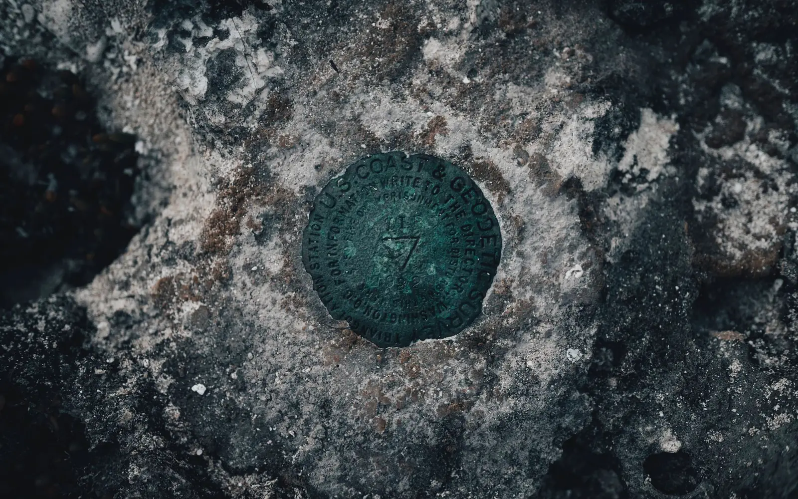
A monument that a licensed land surveyor or civil engineer sets to mark or reference a point on a property line must be marked or tagged with the licensee's number, preceded by "L.S." for a land surveyor or "R.C.E." for a civil engineer. One set by a public agency is marked with the agency's name and the political subdivision it serves (B&P 8772). The tag tells you who set it and helps trace the survey records behind it. The disk in the photo at the top of this article is a geodetic control mark: it marks a survey control point, not a property corner.
Treat a pin you find as evidence, not proof. Construction, grading, fence and utility work, and post-fire debris removal can bury, bend or knock out monuments. Before street, highway or easement work, state law requires the monuments that control boundaries to be referenced by a licensed surveyor, and reset or witnessed afterward (B&P 8771). A pin may also disagree with the recorded map. A licensed surveyor checks a found pin against the records and other monuments before relying on it.
Watch out
Do not pull, move or reset a pin yourself. Setting or resetting a monument that marks a property line or corner is land surveying (B&P 8726), and maliciously removing a boundary monument, or defacing or altering its marks, is a misdemeanor. Neighbors also share responsibility for maintaining the boundaries and monuments between them (Civil Code 841). If a pin is loose or in your way, leave it and ask a licensed land surveyor to reference or reset it.
Fences, hedges and driveways are not proof of the line
A fence shows where someone built a fence. It may sit on the line, inside it or well off it, and the same goes for a hedge, a row of trees or the edge of a driveway. Build a new fence from the surveyed line, not the old fence: just inside the line, or on it by agreement with your neighbor.

A shared driveway may cross a line under a recorded easement, or with no written agreement at all. A preliminary title report lists recorded easements, and a boundary survey can show those that can be located from their written descriptions. On rural parcels, a line described by bearings and distances can run through brush, orchards or slopes, and an old fence there may not follow it.
When a survey shows a fence or building near or over a line, the map documents where it sits. Whether that is legally an encroachment, and questions such as adverse possession or a prescriptive easement, are for the owners and their attorneys.
When you need a licensed land surveyor
In California, locating or retracing a property line, and setting or resetting its monuments, is land surveying (B&P 8726). Only licensed land surveyors and civil engineers registered before January 1, 1982 may do it (B&P 8731). The result is a signed and sealed map, with any filing state law requires made with the county. Call one when:
- You are building or replacing a fence on or near a line.
- A house, addition, accessory dwelling unit (ADU), garage or shop will sit close to a setback.
- Pins are missing, disturbed or disagree with the map.
- You and a neighbor disagree about the line. A sealed map gives both owners, and their attorneys, the same evidence.
- You are buying land and want to see the lines, easements and potential encroachments before closing.
- Your building department asks for a survey.
Some permits require one. The Town of Paradise's residential building permit checklist calls for "1 survey completed by a land surveyor or civil engineer licensed in land surveying," and the Town verifies setbacks at the first building inspection. Rebuilding there? See Paradise & the Ridge for rebuild surveys and plot plans.
The survey that locates your lines is a boundary survey: a sealed map of your lines, corners and recorded easements, with the fences, walls and buildings near the lines.
Before you dig, call 811
A boundary survey locates property lines and corners, not buried pipes or cables, and we do not offer utility locating. For buried lines, call 811 before you dig.
In California, Dig Alert serves Imperial, Inyo, Los Angeles, Orange, Riverside, San Bernardino, San Diego, Santa Barbara and Ventura counties. USA North 811 serves the other 49 counties, including Butte. USA North says calling 811 before digging is a legal requirement in California. Its service is for homeowners and DIYers as well as excavators, and it says to call no matter how deep you dig, because many cables and pipes lie at extremely shallow depths. That includes a hole to uncover a buried pin.
- Pre-mark the dig area with white paint or flags.
- Call 811 at least two working days before you dig, as USA North requires.
- Each utility marks its own lines with paint or flags in a color code.
- Wait until every utility on your request has responded before you start digging.
Utilities mark only the lines they own, and the marking duty does not cover gravity sewer or storm drain lines. Private lines, such as landscape irrigation and lighting, a gas line to a barbecue, or power to a detached garage or shed, are not marked; owners hire a private utility locating company for those.
Property line FAQs
Can I find my property lines myself?
Much of the research, yes: your deed, the recorded map it cites and the county surveyor's records of survey and corner records are public. Locating a line on the ground, or setting a missing corner, is land surveying, which California reserves for licensed land surveyors and civil engineers registered before January 1, 1982 (Business and Professions Code 8726 and 8731).
Are the pins in my yard the legal property line?
Not by themselves. A pin is evidence of where a corner was marked. A licensed land surveyor compares the monuments found with your deed and the recorded map to decide where the lines and corners belong. Pins can be disturbed or disagree with the map; a tag with an L.S. or R.C.E. number shows which licensee set one.
Is there already a survey of my property on file?
There may be. Check the county surveyor's index of records of survey and corner records, and get the recorded map your deed cites. Not every parcel has a filed survey, because state law requires filing only in certain situations.
Can I use my neighbor's survey?
It can help, since you share the line. A record of survey or corner record filed for your neighbor's lot is public and may show monuments on that line. Before you build to it, have a licensed land surveyor confirm the monuments are still where the record puts them.
What happens when a surveyor marks my property lines?
A licensed land surveyor researches the deeds, maps and filed surveys for your parcel and its neighbors, searches for monuments in the field, on neighboring land too where needed (Business and Professions Code 8774), and decides where the lines and corners belong. Missing corners get tagged monuments when that is in scope, and you receive a signed and sealed map. A record of survey or corner record is filed with the county when state law requires.
What this means for your project
- Building or replacing a fence? Locate the line first, then build just inside it, or on it by agreement with your neighbor.
- Building a home, garage or ADU near a line? Setbacks are measured from the property line, not the fence, and required side and rear setbacks for a new ADU are capped at 4 feet (Gov. Code 66314). Start the plot plan for your building permit from surveyed lines.
- Buying land? Have the lines, recorded easements and any potential encroachments mapped with a boundary survey before you close.
Boundary surveys are part of our land surveying services. We are based in Chico and work in Butte County and the northern Sacramento Valley first, and elsewhere in California by arrangement. If you need your lines located on the ground, send us the address or APN and why you need the survey.
Sources
- Board for Professional Engineers, Land Surveyors, and Geologists: 2026 Professional Land Surveyors' Act, Business and Professions Code 8700-8805 (PDF), including sections 8762(e), 8770, 8772, 8773.1 and 8774.5
- California Business and Professions Code 8726: practice of land surveying, including locating property lines and setting monuments
- California Business and Professions Code 8731: civil engineers and the January 1, 1982 land surveying rule
- California Business and Professions Code 8762: when a record of survey must be filed
- California Business and Professions Code 8771: setting and perpetuating monuments
- California Business and Professions Code 8773: corner records
- California Business and Professions Code 8774: surveyor right of entry
- California Civil Code 841: boundaries, monuments and dividing fences
- California Government Code 4216 to 4216.24: excavation notice and utility marking (811)
- California Government Code 66314: accessory dwelling unit standards, including side and rear setbacks
- Sacramento County Assessor: Parcel Maps
- Butte County GIS: Parcels layer description (county GIS portal)
- Butte County Public Works, Survey Department: Recorded Maps layer, the county surveyor's index of records of survey (county GIS portal)
- Humboldt County Surveyor: Survey Monument Preservation Guidelines (PDF, Humboldt County website), on monument types and the state law on removing boundary monuments
- Town of Paradise: Residential Building Permit checklist, with the Land Surveyor's Certification for Building Permit (PDF)
- USA North 811: home page and frequently asked questions
- USA North 811: DIYers
This article is general information, not legal advice. Photos are stock images from Pexels, not projects of American Engineering.


